Wednesday, December 31, 2008

Landscape Turned Cute by Steven Sears and Roebuck

---

My Jan 1 post is up on my toy soldier blog and reflects upon the one manufacturer's ability to find the cute in the Civil War.

Check it out here.

And happy new year to all.

Mannie


Stonewall Jackson confers with S.D. Lee regarding the placement of Confederate aritllery on the Dunker Church plateau (church in background).

---


Tuesday, December 30, 2008

These Boots (were made for walkin')


                                          (not really my foot)
Check this out.

Two years ago I invested in a fabulous pair of Vasque hiking boots, official Ranger trail boots. They're great boots, really expensive, with a really long (really long) break-in period.

Finally, about a year ago, they got comfortable and and were fantastic on the trail.

Here's the O. Henry part of the story.

About a year ago I developed arthritis in the big toe joint of my right foot, within six months I was no longer to get my right boot on or off comfortably.  Eventually I couldn't get it on or off at all.

Now, how's a Park Ranger, who really enjoys hiking, supposed to hit the trail in street shoes? That's just plain bad form!

Today, I got my boots back.

I decided to make a study of the way my foot enters and leaves the boot, and then alter the boot to accommodate the lack of flexibility in my paw.

Here's the shoe making elf in action:

I realized that my foot needed to enter the boot from the rear rather than the top, in the manner of a slipper, so the first step was to open up the seams and cut an entry down the back.


That was a piece of cake, no more whining and grimacing.


Then, with my handy stitching awl, I had to bind up the raw edges.


A line of stitches (white) marks the door "hinge".  The retaining loop was stitched into place...


and the straps measured, cut, and stained.


Holes for the stitching were punched and the first strap stitched into place.  This is the strap that'll close the back of the boot.

This antique harness buckle was stitched to the other, larger, strap, the one that wraps around the ankle and snugs up the whole kit&kaboodle.


The result?  somewhere between Doc Marten and Doctor (Ranger) Frankenstein,


but it fits great and feels fantastic!

See you on the trail (or in the leather craft shop),

Mannie


postscript (two days later)


All systems groovy!

Wednesday, December 24, 2008

Lincoln's Antietam Visit

---
Here, published for the first time, is the Alexander Gardner photograph of Lincoln's visit to Antietam. Though the exchange between the subjects of the photo was never recorded, it is quite clear that a skeptical Lincoln is scrutinizing the books of the AOP.


"...many are the hearts that are looking toward the light, to see the dawn of peace"

Here's looking toward a delightful holiday and a peaceful new year,

Mannie


---

Tuesday, December 23, 2008

Hidden, in plain sight

When I begin my programs at the battlefield I hold up a park brochure opened to the map and say:  "This, isn't the battlefield".  Then I gesture toward the vast bank of windows of the observation room toward the landscape beyond and say "That, is the battlefield".

Now, I know, that's all pretty obvious.  Unfortunately the way we learn history is through maps, flat,  two dimensionally.  Peering down at a map everything seems so clear and understandable, and we find ourselves making judgements about how the various generals comported themselves during the battle, in our very godlike way, towering over it all, bathed in 146 years of combined analysis of the battle, with our handy park brochure.

None of which was available to the generals that actually fought the battle.

The point I try to make to the visitors is that the battlefield, the actual three dimensional one, is a vastly confusing place, and what we view as gently rolling and very beautiful countryside, was seen more as a death-trap for the men who fought here.

Recently I did a little study of some of the terrain features that figured into the first four hours of the battle, the "Cornfield phase" which would range from East woods to Nicodemus Heights. from Poffenberger ridge to beyond the Mumma farm.  Now, believe me, I broke no new interpretive ground here.  This story of terrain is one that has been told by generations of Rangers here at the battlefield, and they all do a better job of it than I ever could. However I'm the one with the camera!

Here are some revealing photos. 


Here I am (nice vest eh?) in the Cornfield, facing east.  Note the very dramatic ridge just behind me.  This ridge has a declination of about five feet and is about two hundred feet long running north-south.


And here's what you see from the other direction:

You are viewing this west of my position, you are looking east with the remains of the East Woods beyond the Cornfield in the foreground.  Imagine if several regiments of your enemy were hidden from your view if you were advancing in this direction.  Or imagine if your regiment, in line of battle, was advancing in a line parallel to the fence, suddenly your left flank or center would disappear from view.  My, how confusing.  Even more so when men are trying in earnest to kill you.

Here I am crouched behind a rock outcropping that runs perpendicular to Starke Avenue due west of the Cornfield.  This ridge is several hundred feet long and has a declination of between two and four feet.


It also has a commanding view of...


the Hagerstown Pike and any unfortunates who would happen to be advancing down it.

This rock ledge is mentioned in several reports and other accounts of the battle.

This rock ledge served as an impromptu fortress three times during the course of the Cornfield fight. Initially, Union troops under Doubleday enfiladed elements Hood’s Division. In subsequent action, Confederates of the 46th North Carolina, commanded by E.D. Hall would enfilade Union troops advancing along the Hagerstown Pike. Due to its commanding position of this rock ledge, relative to the Hagerstown pike, it becomes immediately evident that any troops positioned behind this outcropping possess a field of fire encompassing the road and any troops unfortunate enough to be on it. Ezra Carman, Antietam historian and colonel of the 13th New Jersey led some of those unfortunates and recalled the scene thus; “The men were being shot by a foe they could not see, so perfectly did the ledge protect them”.


The "Disaster in the West Woods", the destruction of Sedgewick's Division in the West Woods by Confederates under Early was due in great part to the fortunate (for Early's men) placement of a ravine system behind the Dunker Church that runs through the West Woods.  Good luck and these ravines would channel Early's men to advantageous positions on the flank and in the rear of Sedgewick's doomed division.  What passes in reports and historic accounts as superb or lackluster generalship is often more the work of chance and terrain.

Deep down in one of the ravines travelled by Early's men.  Seldom did visitors venture into this area.  Now, however the area is accessible on the Park's new West Woods trail.

Finally, one last terrain feature that had an important role in the battle.

This is the view the Confederates had of the Mumma swale on Dunker Church plateau.  This is just behind the Visitor Center.

It looks like an easy advance to the Mumma Farm and points east. 

Your only concern is that little guidon snapping in the breeze.


Not until its too late will you (assuming you are a Confederate) realize that the guidon represents Union General George Sears Green...

and his 1,700-man division concealed from view just beyond the lip of the swale, which will rise up and destroy your regiment.


Make no mistake, I love maps, they are fabulous teaching tools.  But to really understand the battle, there is no substitute for  walking the actual ground and discovering an appreciation ofthe difficulties faced by those who fought over this very dynamic, and confusing landscape nearly a century and a half ago.

Come see for yourself,

Just north of Sharpsburg.

Ranger Mannie

Link to the park's website here

Friday, December 19, 2008

hit "send"


I finished my term paper today and handed it in - virtually that is.  I think it was pretty good.

It was on the impact of terrain on the Cornfield phase of the battle of Antietam.  Surprise surprise!

My first 16 week class ends this week.  Its was enjoyable researching and doing academic writing again, its like using muscles that have been dormant for a while.  

My next class starts Jan 5.  I have two weeks to unstick all of the post-it notes from the pages of my Antietam books.

Looks like during this period of decompression I'll be writing in a more relaxed manner.  My paragraphs will apparently be only two sentences long.

Back to the battlefield tomorrow.

Good night from just north of Boonsboro,


Ranger Mannie

Tuesday, December 09, 2008

Antietam Illumination 2008

Illumination day dawned cold and overcast, and was to get even colder as the hours grew later.  Cold or not, the visitor center was a beehive of activity by the time I arrived.  

No sooner had I settled in, did I get paged that I'd visitors at the front desk.  And I was happy to meet long time blog correspondent Richard and his delightful niece Sarah and friend Samantha.  Sarah became a Junior Ranger this year and is justly proud of her achievement, she's quite a student of the Civil War and both she and Samantha were very charming and bright girls.

After some pleasant conversation we three gathered at the blogger's gun for the photo below.


Richard, Sarah,  Samantha and me.

For a really fine personal view of the Illumination, check out Richard's video here, 
(as well as mine, here).

That day had me so busy I was able to shoot only a few photos, including these:


Illumination day began with Ranger Hoptak setting 23,110 luminaria throughout the battlefield.

Okay, that's a lie.  The actual work is done by over 1,300 volunteers, many of whom have been doing this for twenty years now and they really have it down to a science.


By about four o'clock the volunteers started fanning out across the battlefield lighting the candles in the very cold afternoon.


As the sky grew dark the amazing happened again, those simple brown paper bags, weighted with sand and containing a single candle...


helped us remember each of those 23,110 American casualties of the Battle of Antietam.  September 17th, 1862 remains America's bloodiest day and the day that transformed the American Civil War into a war of liberation.

Its good to remember.

Ranger Mannie

Monday, December 08, 2008

Some jobs...

                (filing a burr from the muzzle of a reproduction Enfield)


...are cooler than others.


Mannie

Saturday, December 06, 2008

The Reason for the Season

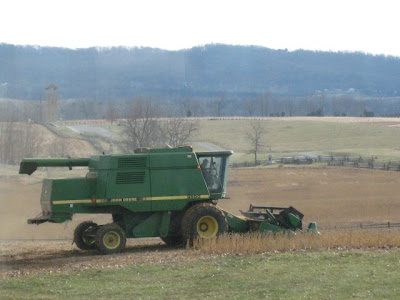
I'm asked frequently, especially around this time of year, why the annual illumination is held in December rather than September.

If one picture is worth a thousand words, then this one taken yesterday, should be quite eloquent:


The soybeans are now all in.  See you tonight at the illumination.

Ranger Mannie

Saturday, November 29, 2008

The Six Cemeteries of Sharpsburg

It is remarkable that a village as tiny as Sharpsburg would be the site of six cemeteries. Some like the National Cemetery are very large, others are particularly small, as in the case of the African-American burying ground known as the Tolson Cemetery.

Let's begin right behind the visitors center just uphill from the Mumma farmstead.

Lying in the heart of the battlefield, on shaded high ground is the always tranquil and inviting Mumma cemetery.

This is the burial ground for the Mumma family and although its surrounded by a gated stone wall, it is always open to visitors seeking shade, cooling breezes, and beautiful vistas.
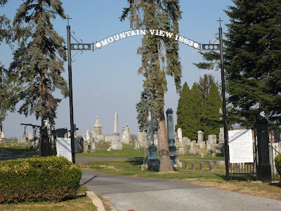


Continuing to higher ground is the town cemetery, Mountain View.

 This is the cemetery that has been the final resting place for generations of Sharpsburg residents since 1883.  From its height you can look north for views of the Piper Farm and the Visitor Center, to the east, as the name implies are vistas of South Mountain and Elk Ridge.


Of course no visit to Antietam National Battlefield would be complete without a stop at the National Cemetery with its ornate front gates and  picturesque Victorian Lodge.

The massive statue of the Civil War soldier, known as Old Simon, stands sentinel over the graves of 4,776 Union soldiers, a continuing reminder of the price of freedom.


Proceeding down the hill toward Sharpsburg, one encounters the Lutheran cemetery.
This cemetery was established in 1768 with the earliest internment dating from 1774.

The church that stood here during the savage fighting of September 17th 1862 is long gone, but the stones still bear silent witness to that terrible fight.


Much of the African-American heritage of Sharpsburg can be found represented in the Tolson cemetery directly behind the Methodist Episcopal Church in Sharpsburg.  Dating back to 1867, the church was founded by and served former enslaved blacks, including...

this member of the U.S. Colored Infantry, a veteran of the Civil War, and a messenger of emancipation.


Finally, tucked off mainstreet, are the stones of the Reformed Church burial ground.  

The first burial was in 1775, the last in 1883 when Mountainview Cemetery opened and became the primary resting place for the good people of Sharpsburg.

Each of these cemeteries has its own special character, and each is equally worthy of a visit. Do seek them out on your next trip to the Valley. Perhaps we'll encounter each other amid the memories.


Ranger Mannie


Free book on the H.L. Hunley

Free book contest at Jim Beeghley's blog!!


And unlike this replica, Jim's offering an book about the actual Hunley

Thursday, November 27, 2008

Looking forward to Christmas tacos

Everyone has their own holiday traditions, for some its going over the river and through the woods to Grandmothers. For Virginia and I, here in the beautiful Cumberland Valley, its a little different.

First a drive down Pleasant Valley to one of our favorite places...


Historic Harper's Ferry and a great hike along the C&O Canal (Two National Parks in one place!)

Then its home to prepare dinner...

my homemade pizza!

We turn it into a holiday trifecta by popping in everybodys favorite holiday movie...


Donovan's Reef.   What a perfect day.

Happy Thanksgiving all!

Mannie

Tuesday, November 25, 2008

Kevin Levin and Jim Beeghley...

have new sites: Civil War Memory 

and Teaching the Civil War with Technology  are both updated in my list of links at right.

Sunday, November 23, 2008

New developments at Antietam

Things are afoot at your National Park.

Remember the big storm last June? (link and video here

The flagpole in the National Cemetery was left askew from those intense winds.  This coming week a new flagpole will be installed and preparations are underway for the heavy lifting.


Also in the cemetery, work continues on the restoration of the historic rostrum, which is being restored to its former glory.  The new timbers are now in place.


Here's some really big news: 

Finally, the Three Farms and Bloody Lane trails are now open.


At last!  the park is connected by hiking trails from north to south.

Trail markers and maps are in position and just waiting for you.
 
Come to the park with your hiking boots and a lunch, pick up a trail guide brochure and hike the entire park, its good for your heart you know.

Staying in shape, Just north (and now, south too!) of Sharpsburg,

Ranger Mannie


Sunday, November 16, 2008

Something I'm doing now


Hey,

I'm producing videos for the park!

Go here and scroll down to where it says:

"click here to see the video"

and see the video.

Then, come out to the battlefield on December 6 to see the real thing.

Ranger Mannie

Friday, November 14, 2008

Its gonna be fine

I encounter, everyday, people who are wishin' and hopin' for a Ranger job of their own, either full-time or seasonal. with Lots of people have a desire to don the green and gray and find a career in our National Parks.

When you consider how few of those jobs actually exist out there it can be easy to get down, disheartened, and discouraged. Lots and lots of talented folks, young and old seem to fall by the wayside. I guess that's just part of the winnowing process.

My advice is to be patient, be flexible, be useful, be ready, and be cheerful.

Add to that advice this encouragement from Glen Yarborough (complete with GoGo girls!).

Lets all hang in there together, there may be a Ranger hat at the end of that rainbow.

Ranger Mannie

Monday, November 10, 2008

Happy Veterans Day...

from my favorite veteran...


Me!

(pictured slightly backwards on Naval Communications Station, Guam, 1971)

Sunday, November 09, 2008

The situation north of here


Is something about to hit the fan up there?

Battlefield barns: a triptych

As the weather gets crisp and the days shorten, its a fine time to reflect upon some of the work that's gone on at the park over the past year. Three projects, in particular spring to mind as they all have to do with big, old, barns; two that belong on the battlefield and one that didn't, sort of.

Starting with the continuing saga of the Joseph Poffenberger barn on the northernmost end of the battlefield. The restoration of this barn has been underway for a year now and the progress is remarkable in both the scope of conservation as well as the skill of the park personnel involved in the undertaking. (click here for deep background)

New siding has been placed over the new upright timbers outside the cattle stalls on the lower level.


Major beams and crossmembers have been hewn, notched and pegged into place on the main floor.


Like pieces in a very large, very old and fragile puzzle, these timbers await their turn.

The Poffenberger farm project was slated as a five-year restoration project, and I must say that they are going great guns on it.


The second barn in this threesome is the Cunningham or Parks barn, severely damaged in the big wind storm that barrelled down the valley back in June (click here for a reminder).

The western end of this original structure was all stove in from the force of the wind, causing this barn to rocket to the top of the priority list.


Repair crews from the Maintenance  Division got in to action immediately to first, stabilize the structure, and then begin the process of repair.


This picture, taken last week shows the barn all healed up  and ready to weather many more storms.


Finally,  the barn that didn't belong.  Actually the foundation of the barn was original to the time of the battle, but the timber overstructure was from much later.  This is the barn right near the Mary Locher cabin on the west side of highway 65.  The time had arrived to remove the top portion and reveal and stabilize the historic foundation walls.
The work provided the drama that heavy machinery is always able to bring to any party.  

First the roofing gets stripped off, and then key timbers are cut, and then...


I was able to hear the Crash! from the visitor center parking lot.


The wreckage was carted away and it became the turn for that little concrete block shed to yield to battlefield preservation.

Presto!  As the remainder of wreckage is removed and the turf heals...


visitors will have this park-like view of the historic barn walls as well as the strategic Hauser Ridge beyond.


And these were just three of the many (many) projects undertaken at the park this year.  I'll post views of other 2008 park projects in upcoming blog entries.

There's always something going on,

just north of Sharpsburg.

Mannie